It sometimes not clear to people whether cycling infrastructure in the Netherlands is a new phenomena or something which has been around decades ago. Sometimes new infrastructure looks "old" or old infrastructure looks "new".
Old infrastructure which looks "new"
Here's an example of a cycle-path and road junction which look right up to date, but which have actually existed for over 60 years.
 |
| Parcels containing bike parts beginning their journey to customers. I use this cycle-path several times a week to transport goods like this because it's a main route from the suburb where we live and work into the centre of the city. Note the re-surfacing work being carried out on the other side of the road. |
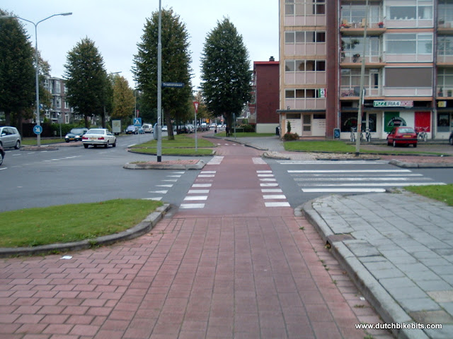 |
| A photo of the same location from 2007 shows an older cycle-path surface and everything looked a bit worn out back then. Tiled surfaces were once quite common on Dutch cycle-paths, this one having survived well past when others had already been replaced. The asphalt came soon after this photo was taken. The cycle-path is in exactly the same location and has the same 2.5 m width, a width which is perfectly fine in most situations for a unidirectional cycle-path, though it would be too narrow if this was intended for bidirectional use. |
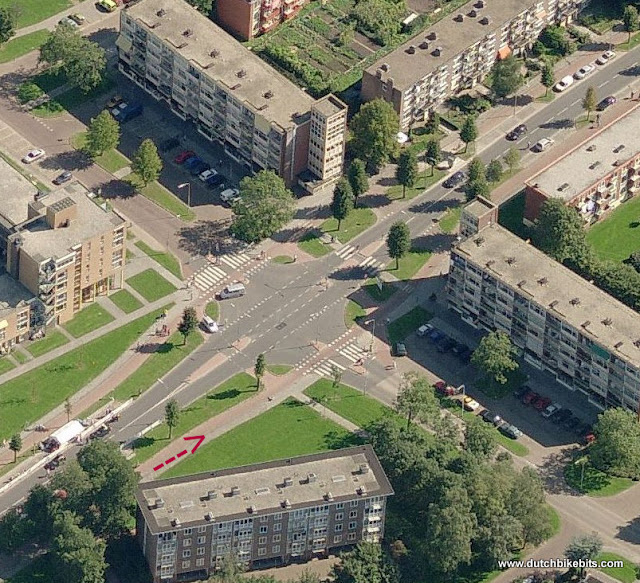 |
| In this aerial shot (courtesy of Bing Maps), the red arrow shows where my bike was when I took the photo above. You can clearly see the road layout here in which motorists give way to the cycle-path as well as pedestrians crossing the road. You can also see the crossings from left to right for cyclists and pedestrians. In that direction, across the main flow, cyclists do not have priority. I've no explanation for the strangely parked vans. |
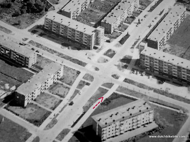 |
| An aerial photo from 1961 shows almost exactly the same layout. The cycle-path is unchanged apart from the surface but the road from left to right has been reduced from a dual carriageway type arrangement to a normal road. When this photo was taken this was not part of a direct route into the city centre because a bridge a few hundred metres further along would not be built for a few more years. Both the bridge for access to the centre and the dual carriageway road arrangement were influenced by a 1913 plan to make a "harmonious" city. The bridge (the current version of which is visible in a recent video) is useful, but it's a very good thing that the idea of building a ring-road this close to the centre was abandoned. |
New infrastructure which required considerable work to look much as it used to
Someone who was transported through time from the 1940s might not initially notice, but it actually took a lot of work to give this road layout a similar appearance to 80 years ago:
 |
| This photo from 2022 shows what looks like a new cycle-path, and indeed it is relatively new, dating from 2008. To the right of the cycle-path is a separate pedestrian path, to the left there's space for car parking, then the road and a canal. Referring to older photos this initially looks like not much has changed. See the next photo. |
 |
This photo from the 1940s already showed the canal, the road, the cycle-path and the pedestrian path. But note that at that time the cycle-path and pedestrian path were both narrower, there was no car parking space and there was no substantive buffer between the road (which had a higher speed limit back then) and the cycle-path. When I took my photo I stood in almost the same position as this photographer stood in when he took his photo, but I'm on the cycle-path and he was on the road. The very similar appearance hides major work to create more space alongside a canal in order to enable us to have better cycling provision as well as car parking spaces required with the considerably higher car ownership rate of the present day.
|
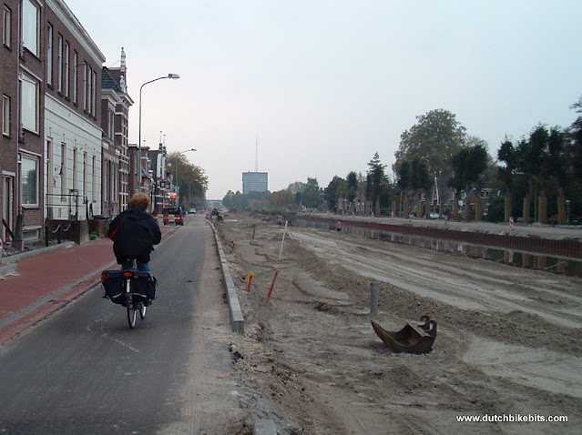 |
| This photo from 2007 facing in the opposite direction (note the same lit up bright red sign on the left) shows where the extra space for the wider cycle-path and car parking came from. The first 1.5 km of the canal running from the city centre to the East was shifted sideways, to the North, by about two metres. Everything was reconstructed from scratch, but the pedestrian and cycle-paths were replaced first and at this point we're cycling on a subsurface (note different colour asphalt from the finished cycle-path). |
So in this case the infrastructure looks like nothing much has changed, but actually it took a lot of work to create a situation where the route looks much like it did in the 1940s while actually offering more to modern cyclists, pedestrians and drivers than was the case before.
New Infrastructure which looks "old"
One of the things which sometimes makes people think that something new is "old" is the road surface, or that streets seem to be very narrow. While tiles on cycle-paths along through routes have often been swapped out for asphalt, as shown above, in city centres the opposite has happened: asphalt is swapped for tiles.
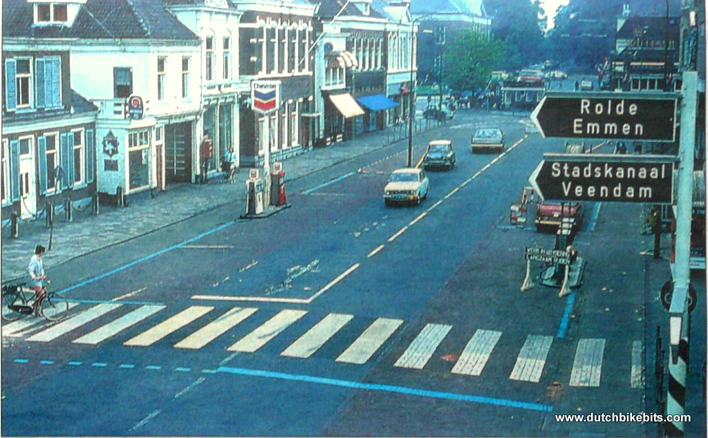
 |
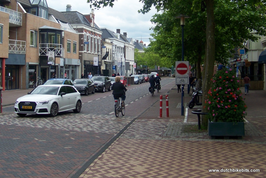
| A city centre street in Assen. Drivers can access this road, but for them this is now a one-way detour to nowhere. No-one drives a car here unless they need to pick something up from one of the shops. This road surface is used by more cyclists than drivers and by bike this is a two way road which provides direct routes to many locations |
 |
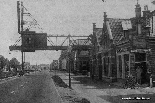
| This is what the same place used to look like in the 1970s. At that time the street looked very wide and it was used as a major through route for cars, as you can see from the signage. Drivers were served by filling stations on both sides of the street. Pedestrians crossing the road had to walk a remarkably long walk to travel between the narrow sidewalks on either side. Asphalt in the middle of the street provided a good surface for driving cars and narrow cycle lanes as the edge provided an inferior surface for cycling. The photo isn't quite wide enough to show the traffic lights which were needed in this location, but which no longer exist. Absolutely no space could be found for trees. If this was still a main route by car in the 21st century it would have become an extremely unpleasant place. |
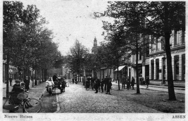 |
| Go back a little further in history and we find that the same street once looked like this. The current layout resembles an attempt to return to how this street looked before it was temporarily taken over by completely car oriented thinking. But what we see now is all completely new and accommodates customers visiting the shops by car, while also excluding the through traffic. Also notice that from the first photo right down to this one people are using similar designs of practical everyday bicycles. This near perfect design has never gone out of date because it works so well. |
What can we learn from this
Initial impressions can be misleading. Sometimes what looks new is old, or what looks old is new.
The Netherlands had cycling infrastructure early in the 20th century, but this was not always valued and there are many examples of early cycling infrastructure being removed in the mid 20th century in order to provide more space for cars. There are also many historical examples of lacklustre infrastructure with inferior surfaces or which took longer routes than driving. It was not until the mid 1970s that the value of cycling infrastructure was recognised again after a series of protests, and it took until the 1980s until the necessity of a full grid of efficient go-everywhere infrastructure was acknowledged, after which quick progress was made.
Click for a more about how this city centre was transformed twice during the twentieth century, first to accommodate more cars and then to exclude them. There are also many more before and after photographs showing how Dutch roads changed over time.


No comments:
Post a Comment